Summer at a desk: Why it is more important than you think

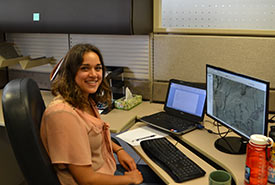
Work behind the computer can still contribute to on-the-ground conservation. (Photo by NCC)
I have always been passionate about nature. My summers have always involved being outside, either for recreation or for work. This summer, however, I have the opportunity to be involved in conserving nature — from indoors. I am the summer geographical information systems (GIS) intern at the Nature Conservancy of Canada (NCC) in Saskatchewan. My work involves digitally creating physical and vegetation boundaries based on the monitoring data that is collected by the area's management team. This information is used in tracking the changes of species and vegetation on the land.
As wonderful and easy as that all sounds, the program is fantastically finicky and often has a mind of its own. Usually the good old “turn it off and back on again” does the trick, as long as you remember to save your work…a lot. So why would I spend a summer staring at aerial photos of vegetation communities and photos of nature when I could be outside doing field work? Because the data I am processing into information will be an important tool for NCC in achieving our conservation goals.
Conservation comes down to decisions. The choices regarding how land is used (or, rather, not used) will impact what our future will look like. Not everyone has the time to visit NCC lands (I highly recommend you do though, just to walk around). Having a digital database makes the knowledge accessible so that conservationists can make informed decisions on the land. Just because you don’t see the species loss does not mean that it is not happening. Conservation of habitat provides species with a chance to survive, and that can only happen if decision makers are aware of what is actually happening in the field.
Prairie conservation efforts are not always glamorous. There are no massive trees to protect or cool mountains to climb in the prairies. However, if you sit still long enough, you would be surprised at how alive native prairie is.
Prior to moving to Saskatchewan, I made my fair share of jokes regarding its lack of nature, but that couldn’t be further from the truth. Saskatchewan has an extremely rich ecosystem; you just have to be willing to look a little closer and drive a little more north than the TransCanada Highway.
In my opinion, all small prairie life is super cool. Scientists and conservationists don’t just identify plants and watch animals because it is neat (although it is). They collect and identify all of this field data to understand how many species use habitats on NCC’s properties. The data helps create a baseline of how active a habitat is. Taking field data, synthesizing it and communicating it allows for science to be transformed into conservation, which can lead to positive change.
So how does NCC use all of this data? Well, if you have ever wondered why NCC chose to plant a specific type of tree or conduct a controlled burn, these decisions are determined by field data, GIS data, species data and any other information that staff can use.
Mapping data in GIS gives an aerial view of NCC properties, but it it also gives a bird’s-eye view of the science. It isn’t possible for conservation staff to know every little thing about all natural areas. And so GIS-based programs allow scientists to see an accurate summary of what is happening in the real world and the changes that happen year to year. GIS allows those not directly associated with properties to be let in on the most up-to-date information about NCC’s properties. Only through clear communication of information can smart conservation happen.
NCC staff make sure that I get to connect with the properties in person. So although the majority of my days are spent trying to align different boundaries of land features, I know that the work done behind the scenes allows for new projects to move ahead smoothly as information is formatted and easily accessible.
I’ve grown more appreciative of the time I do spent outside and how thankful I am that there are recreational spaces nearby that are conserved. I still like to be outdoors, and I have already been lucky enough to get out in the field this summer. But as I sit in the office updating GIS maps, I feel confident that I am contributing to conserving the outdoors that I love so much.
The Conservation Internship Program is funded in part by the Government of Canada’s Summer Work Experience program.


