Bending Willow Creek: Meandering through Minesing

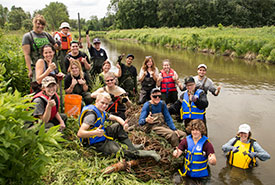
Volunteers at NCC's River Bends on the Mend CV event. (Photo by Miguel Hortiguela)
It was the summer of 1982 and I'd just finished my first of three years in the Fish and Wildlife Technology program at Sir Sandford Fleming College (since re-branded as Fleming College) in Lindsay, Ontario. I'd been offered a summer job with the Metro Region Conservation Authority (MTRCA, since re-branded as Toronto Region Conservation Authority) to join a crew of four that would spend the summer conducting surveys and rehabilitation projects along two reaches of streams within the MTRCA's jurisdiction. I was in heaven.
Fast forward to late spring of 2015, and while perusing the various projects the Nature Conservancy of Canada (NCC) was planning within a short driving distance of my home in Toronto, my eyes fell on an opportunity to reprise that wonderful summer. The event was described as River Bends on the Mend and the waterway requiring our help was Willow Creek, which flows through the Minesing Wetlands.
Minesing is a word of Ojibwe origin meaning "island,” referring to an island located within Lake Edenvale. The present-day Minesing Wetlands and surrounding areas are recognized internationally as a significant Ramsar boreal wetland.
Minesing's very existence depends on the careful management of the numerous waterways feeding its sensitive ecosystems. Waterways naturally meander as they follow the path of least resistance, flooding depressions, overflowing and hugging contours as they slope toward ever larger bodies of water. Short-sighted alterations to our physical environment usually impact negatively on natural systems that support a variety of plant and animal life that has evolved over time to depend on these systems. It really is a fine balance.

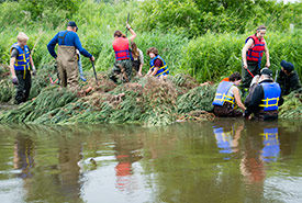
Volunteers install deflectors along Willow Creek. (Photo by Miguel Hortiguela)
Our objective for the day was to reintroduce a few curves to Willow Creek along a stretch of river that flows adjacent to George Johnston Road. This length of the creek had historically been straightened, dredged and over-widened to ostensibly improve drainage of the surrounding area. Unfortunately, it also compromised the geomorphology of the creek, the dissipation of sediment and altered habitat features.
Despite the rainy forecast and probability of getting wet, more than a dozen volunteers, eager to contribute their brawn to the effort, met at the rendezvous point. There we were welcomed by Laura Robson, acting coordinator of conservation biology in NCC’s Georgian Bay-Huronia sub-region.
Together with Shannon Stephens, Healthy Waters program coordinator for the Nottawasaga Valley Conservation Authority, Laura described how we would build temporary, artificial wing-deflectors at several points along the stream banks, thereby introducing new curves in the creek's flow.
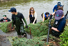
The deflectors were constructed from Scots pine trees donated by Somerville Nursery that had been destined for the Christmas tree market but were no longer needed. Volunteers layered the trees along the river bank with the stumps pointing slightly upstream at a 45-degree angle. They were secured in place by driving and anchoring a heavy gauge cable with a swivel-lock on the end deep into the riverbanks, and the other end wrapped around each tree and secured with a crimped metal clip.

Volunteers working to put the bends back into Willow Creek. (Photo by Miguel Hortiguela)
Not only will the intertwined nature of these structures trap sediments suspended in the water column that would otherwise blanket the creek bed further downstream, but they will subsequently provide an organically rich seed bed for vegetation. Earlier, I referred to these structures as temporary; over time they will become permanent, overhanging riverbanks. This is critically important to fish species seeking shelter from the hot sun and predators.
As these structures gently protrude into the creek, they will gradually help to narrow the waterway thereby increasing flow rate, flush suspended solids, deepen the watercourse, cool water temperature, raise oxygen levels and provide a healthier habitat for aquatic and terrestrial life alike.
It really is a fine balance.


