Beth McLarnon-Nature Conservancy of Canada, Data and Information Coordinator & Emilie Brien-Nature Conservancy of Canada, Natural Area Manager

Deer (Photo by Reconyx Wildlife Cameras)
Linking Landscapes: Monitoring Wildlife in the Jim Prentice Wildlife Corridor
The Nature Conservancy of Canada (NCC) and Miistakis Institute are establishing a wildlife monitoring program to inform wildlife management in the Jim Prentice Wildlife Corridor (JPWC) in the Canadian Rocky Mountains, with technical support from the Alberta Biodiversity Monitoring Institute. The JPWC represents an essential space for wide-ranging mammal species in the Canadian Rocky Mountains. The region represents important winter habitat for large ungulate species, a rare east/west movement opportunity at lower elevation, and critical north-south movement across the highway.
A wildlife camera-trap study in the JPWC can supplement existing reports and previously completed work to improve our understanding of what areas are being used by species that move through the area. This will allow a comparative analysis between species data, animal vehicle collisions (AVCs) data and the logistics of implementing mitigation within the JPWC due to competing land uses.
What is the problem you are looking to solve or the question you are looking to answer?
The Highway 3 transportation corridor bisects the JPWC, and connectivity is further complicated by plans to realign portions of the highway. This includes an upgrade to four lanes, branching from the existing highway alignment from the town of Blairmore and merging back into existing Highway 3 alignment within the eastern portion of the JPWC. The proposed new highway alignment and end terminus will likely have impacts on wildlife movement within the JPWC unless the appropriate mitigation efforts are put in place to facilitate safe movement of wildlife across the highway. In addition, over time, traffic volumes are projected to increase along Highway 3. Projected increase in traffic volumes will increase both human safety risk and wildlife mortality from AVCs.

Camera setup (Photo by Emilie Brien)
Creating a wide-ranging mammal monitoring program that can be used to support existing tools and information that are available to those making policy or road-planning decisions is a key part of this project. Information generated will support those tasked with local property management (for both private and public lands) and future conservation decisions.
What is the impact you are hoping to achieve in Alberta (or beyond) with the project you are involved with?
Working with partners to make recommendations on the most appropriate mitigation measures for improving, supporting and enabling wildlife movement across Highway 3 within the JPWC (north-south) and along the valley bottom (east-west).
What will you learn from your project?
The data outcome from the Linking Landscapes project will be finding patterns in wildlife movement and pinpointing areas that could be used as potential highway mitigation. But equally important, the Linking Landscape team will be able to work with the countless volunteers who are already making the project possible and learn what the power of community support can accomplish.
What is the project’s biggest achievement to date, or what are you looking forward to achieving in the coming months?
As of the end of January, the project team has secured permits/permission for all camera locations and deployed over 95 per cent of the camera setups. The deployment and permit process for 33 cameras within a limited window has been a great success for the Linking Landscapes project. The team was able to successfully work with 10 different land partners to access our preferred camera locations, including NCC, two Alberta Government departments, three private landowners, two lease holders, one land steward and one large company.
How can this project benefit NCC’s work and support other conservation initiatives?

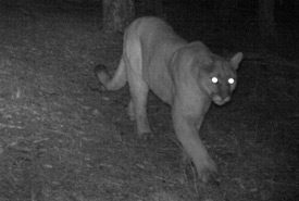
Cougar (Photo by Reconyx Wildlife Cameras)
Datasets derived from camera-trap observations can be used to pinpoint the areas most frequently used by wildlife to support land conservation and land management decisions (private and public).
What is your favourite part of the project you are working on?
The animals! Each camera has a unique opportunity to capture animals going about their normal lives. Though much of what you capture is focused movement through an area, you sometimes find a special series of photos, like two foxes playing in front of the camera.
What gets you excited about the species, habitat or theme your project is investigating?
The most exciting aspect of the project is to contribute to previously collected data on animal movement within the corridor. The data will create the clearest picture possible of which species are using the JPWC and where there is evidence for preferred highway crossing locations. Being able to recommend mitigation areas to decision makers could improve the living conditions for many species that call the JPWC home.
A fun fact to share:
The volunteers for the Linking Landscapes project are incredibly keen! We had some delays with the training because of the COVID-19 restrictions, and many volunteers kept asking when they could start. We even have volunteers who went out in the field to find their cameras by themselves!


