Mapleleaf Mussel Conservation

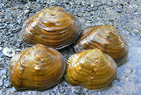
Mapleleaf mussels. Photo by Scott Gibson via iNaturalist
Mapleleaf conservation – NCC in Manitoba
The mapleleaf is a mid-sized freshwater mussel that historically occurred in central and eastern North America. Adults are about the size of a deck of cards and look a little like a maple tree leaf, with their squarish shape and the vein-like raised ridges on their shell. These features can help in identifying this species apart from other mussels; however, they are not often seen as they live on the bottom of medium to large rivers where they filter water for microscopic food.
Within Manitoba, mapleleaf have been observed within the Red River and its tributaries. Recent evidence suggests that their populations are in decline. Their persistence is often only known when fresh empty valves (shells) are found, indicating recent die offs. The population of this species in Manitoba was listed as Endangered under Manitoba’s Endangered Species Act and is listed as Threatened within the federal Species at Risk Act (SARA).
In 2021, with funding support from Fisheries and Oceans Canada’s Habitat Stewardship Program, the Nature Conservancy of Canada (NCC) in Manitoba initiated a three-year project focused on monitoring and improving mapleleaf habitat in southern Manitoba.
Mapleleaf surveys
NCC is partnering with the Manitoba Conservation Data Centre (MBCDC) to complete standardized surveys for freshwater mussels in rivers and creeks near NCC projects. In 2021, MBCDC staff surveyed 14 sites throughout southern Manitoba, and habitat characteristics were recorded to better understand how land stewardship activities can benefit Manitoba’s mussel species and their habitats. Surveys will be continued in 2023.
Enhancing mapleleaf habitat
To improve mapleleaf habitat, the project has two main areas of focus. The first is to improve water quality within streams and rivers on NCC properties by reducing access to aquatic habitats by grazing livestock, while ensuring this important management tool can still be used to maintain biodiversity in the adjacent grassland habitats.
Many NCC properties feature grasslands that would have historically experienced natural disturbance by grazing animals, such as bison, or by fires. Such disturbances are important for cycling nutrients, maintaining plant diversity, and preventing the establishment of shrubs and trees within the grasslands. Historical disturbances have been nearly eliminated from present-day landscapes, so NCC often relies on livestock to maintain these disturbances. Using grazing to manage grasslands on NCC properties also benefits local economies by providing local producers with a source of forage for their herds. However, the presence of livestock can sometimes introduce problems to adjacent wetlands and waterways when livestock concentrate in them as a water source, and may impact habitat quality for species such as the mapleleaf.
Two NCC sites supported by this project, Fort Ellice and Waggle Springs, have prairies that are maintained with grazing, and feature waterways that provide suitable habitat for mapleleaf. NCC also uses grazing to manage grassland in areas supporting tributaries and headwaters upstream of habitat supporting the species, including one site near Inglis. Although this property is further from known mapleleaf populations, management activities within the watershed can have implications for water quality downstream within the watershed, where mapleleaf occur. Previously, livestock had unrestricted access to waterways as their main source of water. Funding for this project has allowed NCC to purchase materials and hire local contractors to install over two kilometres of wildlife-friendly fencing along the waterways on these properties to exclude livestock in sensitive areas, and install moveable watering systems, which provide alternative water sources for grazing livestock.
Increasing habitat connectivity
The second area of focus is to increase access for mapleleaf mussels to suitable habitat. For example, NCC’s Fort Ellice property has a 50+ year old concrete ford on Beaver Creek, which acts as barrier to potentially suitable mussel habitat. Individual mussels cannot move large distances in their adult stage, but during their larval stage, they can travel enclosed within cysts in the gills of channel catfish for a portion of their development and re-establish in areas where channel catfish travel. Channel catfish are known to occur in the Assiniboine River, in areas adjacent to Fort Ellice, and can be found in clear-running streams with deeper pools, like those found throughout Beaver Creek. However, the concrete ford in the creek presents a barrier to upstream movement for channel catfish and, as a result, to mapleleaf as well.
NCC contracted engineers to develop concepts to modify the barrier which is still needed to access portions of the property. The resulting report provided modification options that consider short and long-term costs, permit requirements, operation and maintenance, hydraulic and environmental impact, while also requiring designs that will increase upstream passage by all fish found in the stream.
The next phase of the project is now underway, which includes developing the plans for a rock ramp with boulder garden on the downstream side of the existing concrete barrier. This modification will improve connectivity within Beaver Creek and the Assiniboine River, enhance approximately 28 hectares of fish habitat, and remove a barrier to accessing upstream habitat by fish and associated species such as the mapleleaf. Plans are underway to complete the installation in late 2023 or early 2024.
This project was made possible through the support of:


