Fishing Lake and Young's Island

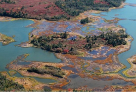
Young's Island in Musquodoboit Harbour, Eastern Shore, NS (Photo by Mike Dembeck)
The Nature Conservancy of Canada (NCC) conserved two sensitive ecological areas in the Eastern Shore Region — including one that without NCC’s involvement was destined to be cleared and developed for cottage lots.
Fishing Lake is located approximately 50 kilometres east of Halifax. The lake itself is long and narrow, with a rocky shoreline, and measuring over four kilometres in length and 350 metres wide on average.
The 188-hectare (465-acre) property surrounding Fishing Lake is entirely surrounded by other conservation lands, making it a high priority acquisition for the Nature Conservancy of Canada. By conserving it NCC is helping to connect these areas, provide a larger area for wildlife to roam, and maintain a healthy biodiversity in the region.
The Fishing Lake property is dominated by Wabanaki (Acadian) forest and contains some of Nova Scotia’s last remaining wilderness. It contains red spruce, black spruce and balsam fir with stands of tamarack in wetter areas. The landscape also supports some endangered species, including moose, wood turtle and sensitive boreal felt lichen.
Area was targeted for cottages
Nature Conservancy of Canada's Nova Scotia program director, Craig Smith, says it was important for NCC to purchase Fishing Lake quickly because of the high threat of development from its owners, who are based in the United States.
“Their original plan was to subdivide the land into cottage lots but in our discussions, we brought a strong case for conservation to them. Rather than sell lots for cottage development, we felt it should be conserved,” said Smith. “Since the Fishing Lake property is completely enclosed by protected wilderness area, subdivision and development would have had a great impact on the ecological integrity of the surrounding protected lands.”
Fishing Lake at a glance
- 188-hectare (465-acre) parcel encompassing 95 percent of the Fishing Lake shore;
- Nestled within Ship Harbour Long Lake Wilderness Area;
- Includes extensive conifer forest, riparian wetlands and 10 kilometres of shoreline.
Young's Island - Musquodoboit Harbour project:
This 34-hectare (84-acre) island north of Martinique Beach is located within the Musquodoboit Harbour Estuary, approximately 30 kilometres east of Halifax. The outer estuary is a designated a Ramsar Wetland of International Significance.
Young’s Island is a coastal island with intertidal wetlands, extensive salt marshes and mudflats. It contains a mix of coastal forest and barrens that support significant waterfowl, bird and marine life. The coastal forest here is reminiscent of the northern Boreal forest, containing mostly black spruce and balsam fir.
Since 2000, NCC has been working with partners in this area, protecting a total of 546 hectares.
Natural area
The Eastern Shore region of Nova Scotia contains an outstanding assemblage of biodiversity features, including extensive and rich coastal ecosystems, conifer-dominated Wabanaki (Acadian) forests and a large network of freshwater lakes and streams. All provide habitat for a diverse flora and fauna.
Some of Nova Scotia’s largest remaining intact forests are found here. The Musquodoboit River, which runs through the natural area, is the richest river valley in this region of the province. Its banks contain rich floodplains and adjacent wetlands, a comparatively healthy population of Atlantic salmon as well as several populations of federally threatened wood turtles and provincially sensitive sea-run brook trout.
Sandy beaches throughout the area provide breeding sites for the endangered piping plover and rocky shorelines provide habitat for the Harlequin Duck, which winters in small numbers along the coast.


